Interactive map shows National Trust areas at risk of climate change
- Published
- comments

Ham House in London could reach extremely high temperatures if nothing is done, which is why the National Trust is planting more heat resistant trees to provide shade in the summer months
A new interactive map produced by the National Trust, which looks after lots of the UK's sites of natural and historical interest, shows that many of its popular locations could be under threat from climate change.
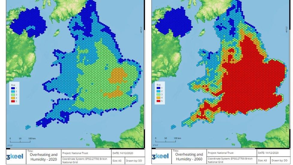
The map illustrates the potential risks that may be caused by issues like coastal erosion, extreme heat and flooding and shows the number of National Trust sites under threat may increase over the next 40 years.
However, the map shows the worst-case scenario, which means it demonstrates what could happen if nothing was done to drive down global carbon emissions.
The National Trust warns the number of its sites facing a high level of threat from issues such as coastal erosion, extreme heat and flooding could rise from 5% to 17% over the next 40 years.

The map on the left shows the risk of over heating and humidity in 2020 and the map on the right shows the worst case scenario of what could happen in 2060, if no preventative measures are put in place.
Many initiatives are being put in place to stop the worst happening, including tree planting and saving more peat bogs to prevent flooding.
The charity say that these maps are a "game-changer" because they show the areas that require more attention from conservation projects.
The National Trust director for land and nature Harry Bowell said that "by acting now, and working with nature, we can adapt to many of these risks."
And staff are already acting upon areas that are experiencing problems.
For example, at Ham House in London, more hardy plants that are used to hot conditions are being planted. These will provide more shade in areas that the map shows could reach up to 40 degrees C by 2040.

Areas of Mount Stewart in Northern Ireland have been at risk of coastal erosion and rising sea levels recently
Meanwhile trees are being planted at Lyme Park in Cheshire after areas were hit by flooding in 2019.
In County Down in Northern Ireland, a car park for Mount Stewart, a stately home, has been moved away from the coastline as erosion and rising sea levels were causing issues.
The charity wants to plant 20 million trees before 2030, and said the map will ensure trees are planted where they are needed most.
- Published4 December 2020

- Published12 June 2019

