Q&A: Latest volcanic ash plume
- Published

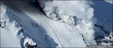
Fresh activity over the weekend resulted in the production of a fresh ash plume
The ash is back. Fresh volcanic activity under the Eyjafjallajokull glacier in Iceland has resulted in a fresh ash plume being pushed about 5.5km (18,000ft) into the air.
Weather conditions had led to a concentrated cloud of ash reaching northern parts of the UK, as well as the Irish Republic. As a result, aviation authorities started banning flights from airports in affected areas on Tuesday and the disruption - which is changeable - continued on Wednesday.
Airspace over Europe was closed down for six days last month because of fears of the effect of volcanic ash on aircrafts' engines.
What has caused the latest ash cloud?
The latest plume was the result of a fresh pulse of meltwater and ice from the surrounding glacier entering the volcano, explained Haraldur Olafsson, a professor of atmospheric sciences at the University of Iceland.
Professor Olafsson said it was similar to the events that generated April's massive ash cloud that spread across much of Europe.
"In the early phase of the eruption, there was a lot of meltwater and ice, which contributed to the explosions, which in turn contributed to a lot of solid material being pushed very far up into the atmosphere."
He added that there was still a lot of meltwater that could cause further plumes to be pushed into the atmosphere.
"It is not finished yet. Sooner or later, this is going to stop, but this is not imminent."
What is the advice for people planning to travel by air?
The situation is unclear for many travellers.
In a statement on Wednesday morning the Civil Aviation Authority (CAA) said: "The situation remains changeable, so passengers expecting to travel from airports in Scotland, Northern Ireland, the north of England and north Wales should contact their airlines to check whether their flight is operating."
It said a 60-nautical-mile buffer zone imposed around high concentrations of ash in the skies may be close to Carlisle, Blackpool, Liverpool and Manchester airports - although those remained open for the time being.
At just after 0700 BST, Andrew Haines, chief executive of the CAA, told the BBC the risk of closures in much of the UK was likely to recede during the day.
A spokesman earlier said the CAA, along with air traffic control agency Nats, was monitoring the situation very closely and taking advice from the Met Office.
The CAA - which is providing updates on its website, external - said it would report again on Thursday morning when further Met Office forecasts became available.
Based on current forecasts, it said it did not expect airports in the south-east of England to be affected on Thursday.
Is it as bad as last time?
Professor Olafsson said the volume of ash being emitted was less than April's eruption, but it still had the potential to cause problems.
Data gathered by Icelandic researchers monitoring the situation showed that the ash cloud was heading south-east.
"The current plume is very concentrated as the ash is transported towards the British Isles," he told BBC News on Tuesday.
"It is reaching heights of about 5km and is not showing much sign of dispersing."
Aviation authorities took the decision to temporarily ground flights to and from some airports in Northern Ireland, the Irish Republic and Scotland as the concentrations of ash exceeding safe levels passed through a part of the islands' airspace.
Professor Olafsson said that he was aboard a German research aircraft that flew through the plume on Sunday.
"Measurements showed that the most concentrated part of the cloud was only about 100km wide, but it was definitely too concentrated for any aircraft to go into the middle of it."
The ban was lifted on Tuesday lunchtime, after the concentration of ash was deemed to have dispersed enough, but was then imposed again on Wednesday morning.
Even when flights resumed on Tuesday the CAA said a number of safety measures remained in place, such as inspecting aircraft engines before and after each flight for possible ash damage.
The CAA also said the situation remained under constant review because the Icelandic volcano is still emitting a plume of volcanic ash.
How long could the current ash cloud cause problems?
It is uncertain at this stage.
On Wednesday morning the Met Office said the winds were expected to change on Thursday, pushing the ash away.
They said the volcano had remained active, and north/north-westerly winds were bringing the ash from Iceland across towards Scotland.
This will remain the case on Wednesday, but on Thursday, Friday and Saturday the direction of winds over the British Isles will change to north-easterly, bringing in clean air and pushing the ash away.
The Met Office says this is different to the April ash cloud situation, when the wind travelling north/north-west from Iceland remained for several days.
They say that as long as the volcano keeps erupting, every time there are strong north/north-westerly winds there is a risk of high concentrations of ash in the skies.
There is a possibility these winds will return for a time next week, bringing more ash.
The latest forecasts and guidance can be found on the Met Office's Volcanic Ash Advisory Centres website, external.