Summary

Media caption,

Damage and disruption as Storm Floris crashes into UK

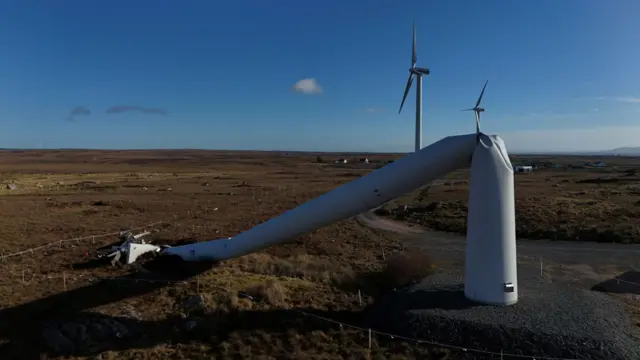
  1. ScotRail warns of 'significant disruption'published at 08:21 British Summer Time 4 August

    ScotRail train with company logo, window reflecting passengers on a platformImage source, PA Media

    David Ross of ScotRail has been speaking to BBC Radio 4's Today programme about the major disruption facing passengers today.

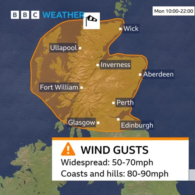
    There are speed restrictions across the whole network because of the amber weather warning, he says.

    "That means we will operate significantly fewer services than we normally would, and across a number of routes there will be no services at all throughout the course of the entire day."

    He says the advice to passengers is to take a look at the ScotRail website or the app, to see exactly what’s running and when.

  2. What does an amber weather warning mean?published at 08:14 British Summer Time 4 August

    Elizabeth Rizzini
    Lead weather presenter

    An amber warning is in place from 10:00 BST across much of Scotland. It is the second highest level of alert issued by the Met Office.

    It means that a particular weather event is not only likely to happen but that it will have a high impact too.

    It's likely that plans will be disrupted by the weather with the possibility of travel delays and cancellations, there could be power cuts and there is a potential risk to life and property.

    Within the amber warning area, Storm Floris is likely to lead to road and bridge closures and travel delays from the strength of the wind. There will be large waves in coastal areas with beach material being thrown onto seafronts. There could be damage to trees and buildings such as tiles blown from roofs. Flying debris could lead to injuries or danger to life.

    The wind will also be accompanied by heavy rain.

  3. Are you feeling the impact of Storm Floris? Get in touchpublished at 08:04 British Summer Time 4 August

    Banner that says Your Voice Your BBC News.

    With winds of up to 70mph in coastal areas forecast for today, we want to hear how you have been impacted.

    We also want to see your pictures of the stormy weather from the across the UK.

    You can contact us in the following ways:

  4. Why do we name storms?published at 08:03 British Summer Time 4 August

    Matt Taylor
    BBC Weather

    The Met Office started naming storms in 2015.

    Areas of low pressure are generally only named when it is anticipated that they will bring significant impacts or disruption to daily life. However, due to the naming process, some named storms may be more notable than others.

    Across Europe, various national weather services group together to name areas of low pressure that are forecast to have impacts in their part of the continent.

    For us, the Met Office collaborates with the Irish and Dutch weather services. This means that some named storms may have their most significant impacts in Ireland or the Netherlands than here in the UK. Presenters take this into account when delivering the forecast.

    Naming storms has been shown to improve awareness of severe weather and helps forecasters to provide easy to follow and consistent messaging.

    The list of storm names is announced on 1 September each year and runs in alphabetical order, starting this season with Ashley, followed by Bert, then Conall, Darragh, Éowyn and now Floris.

    A wind turbine that was blown over during Storm Eowyn, in Inverin, Ireland, in JanuaryImage source, Reuters
    Image caption,

    A wind turbine that was blown over during Storm Eowyn, in Inverin, Ireland, in January

  5. Festivals and fringes impacted by stormpublished at 07:51 British Summer Time 4 August

    The organisers of Fringe By The Sea in North Berwick, East Lothian, have announced the cancellation of today's events due to Storm Floris.

    They say the festival, which runs more than 250 shows from 1 and 10 August, will reopen on Tuesday at 10:00 BST.

    Edinburgh City Council has also announced that Princes Street Gardens will be closed on Monday and Tuesday as a precaution, leading to the cancellation of some Edinburgh International Festival events including Monday's ceilidh sessions.

    Meanwhile Edinburgh Fringe Festival are monitoring the impacts of the "evolving storm", they say: "Should a show be cancelled our customer services team will be in touch with customers who have purchased tickets... we will update advice and guidance throughout the day tomorrow."

    Edinburgh Fringe Festival 2025 began on Friday with large crowds descending on the Scottish capitalImage source, Getty Images
    Image caption,

    Edinburgh Fringe Festival 2025 began on Friday

  6. From the US to the UK: Where Floris came frompublished at 07:47 British Summer Time 4 August

    Matt Taylor
    BBC Weather

    A thunderstorm in New York City, as seen on ThursdayImage source, Getty Images
    Image caption,

    A thunderstorm in New York City, as seen on Thursday

    On Thursday morning a band of intense showers and thunderstorms crossed to the south of the Great Lakes in the US. By Friday storms raged across New York and New Jersey causing widespread flooding and disruption.

    These amalgamated into a developing area of low pressure over the western Atlantic which, over the weekend, has been picked up by a jet stream approaching 200mph in speed and transported towards our shores.

    The crucial bit for us is that the area of low pressure is now interacting with part of the jet stream which helps to deepen it rapidly, causing winds wrapped around the low to increase dramatically.

    And the timing of that is such that the strongest winds will be as the low crosses Scotland today.

  7. The grey before the stormpublished at 07:35 British Summer Time 4 August

    It's a gloomy start for many people in northern parts of the UK this morning - at least that's the picture we're getting from our Weather Watchers:

    Ships moored in the sea surrounded by low, wet cloudImage source, happydays/ BBC Weather Watchers
    Image caption,

    Plockton, Highlands

    Grey skies hang low over a green fieldImage source, Beckas Camera/ BBC Weather Watchers
    Image caption,

    Ballynoe, Newry Mourne And Down

    Lighthouse in grey skies in MontroseImage source, Simon/ BBC Weather Watchers
    Image caption,

    Montrose, Angus

  8. Trains cancelled north of Newcastlepublished at 07:22 British Summer Time 4 August

    LNER train on platform, worker in orange outfit stands on the side of the tracks.Image source, Getty Images

    London North Eastern Railway (LNER) says services won't run north of Newcastle today.

    "LNER are advising that customers do not travel north of Newcastle until the end of the day. All stations north of Newcastle will not be served."

    The train operator say that alternative travel options will be extremely limited due to expected road closures - and point out that other rail networks will also be affected.

    Scotrail have put a 50mph speed restriction in place as they warn Storm Floris will bring disruption.

    They say "significantly fewer" services will run, some lines will be closed all day, and some routes will stop running around lunch time. Customers are advised to check the ScotRail app and website for updates.

    Avanti West Coast has advised customers not to travel north of Preston today as they say their routes from England into Scotland are expected to be heavily affected by Storm Floris.

    Affected destinations north of Preston on their route include Lancaster, Oxenholme, Penrith, Carlisle, Lockerbie, Motherwell, Haymarket, Glasgow Central and Edinburgh.

  9. A 'wet and miserable' morning in Gourockpublished at 07:13 British Summer Time 4 August

    Speaking in a rainy Gourock, Inverclyde, the BBC's Jamie McIvor says it's the severe wind later which is going to cause the major disruption.

    Media caption,

    'It's certainly wet and miserable at the moment'

  10. Today's Edinburgh Tattoo performance cancelledpublished at 07:01 British Summer Time 4 August

    Edinburgh Military tattoo with people in kilts playing bagpipes.Image source, PA Media

    The Royal Edinburgh Military Tattoo performance on Monday has been cancelled due to the weather warnings.

    In a statement, Edinburgh Tattoo said "we understand this will be disappointing, but the safety of our audience, performers and staff is our top priority".

    They say that all tickets for the performance this evening will be automatically cancelled and refunded, adding: "We currently expect to go ahead as usual on Tuesday 5 August, but we will continue to monitor the weather and provide any further updates on our website and social channels."

  11. When will the winds peak?published at 06:49 British Summer Time 4 August

    Matt Taylor
    BBC Weather

    The peak winds are likely to be across the Western Isles, Skye, Ross and Cromarty between 10:00 BST and 13:00.

    Winds gusts in these areas could widely hit 70-80mph, perhaps even touching 90-100mph for a time.

    Between 12:00 and 15:00 the strongest winds will have transferred to the north-east of the country, with areas of Caithness and those bordering the Beauly and Moray Firths most likely to see winds get close to, or exceed 80mph or 90mph.

  12. Will the winds be strong everywhere?published at 06:43 British Summer Time 4 August

    Matt Taylor
    BBC Weather

    The strongest winds will be across the Western Isles and the north of mainland Scotland, but disruptive and possibly damaging gusts of 50-70mph could be experienced across a large part of Scotland, from the Central Belt northwards.

    All these areas are covered by a Met Office amber warning for wind.

    However, wind gusts could still have impacts across the far south of Scotland, Northern Ireland, Isle of Man, northern England and north-west Wales - 40-50mph gusts can be expected widely, but possibly as high as 70mph on some coasts, bridges and hills.

    For the rest of England and Wales, while generally blustery conditions and a spell of rain can be expected, the storm is not expected to have significant impacts.

    A map showing the location for the amber warning in Scotland
  13. Weather warnings in force as UK braces for Storm Florispublished at 06:40 British Summer Time 4 August

    Matt Spivey
    Live reporter

    A beach in Scotland with grey sky and gloomy weather over the sea, rocks in the foreground.Image source, Hopeman/BBC Weather Watchers
    Image caption,

    In Moray, north-east Scotland, it's a gloomy start to the day

    Good morning from the newsroom in London.

    Parts of the UK are bracing for Storm Floris, with an amber weather warning for large parts of Scotland due to come into effect at 10:00 BST.

    A yellow weather warning is already in place across northern England, north Wales, Northern Ireland and other parts of Scotland, and will remain until midnight on Monday.

    High winds could pose a "danger to life" and travel disruption is expected - some train and ferry services have already been cancelled.

    Many inland areas are likely to see gusts of 40 to 50mph with 60 to 70mph possible along exposed coasts and high ground.

    Storm Floris is the sixth named storm of the 2024/2025 season. We'll bring you the latest updates from our teams across the UK throughout the day, so stay with us.