Summary

  • Hurricane Ian made landfall for a second time in the US after devastating Florida - hitting South Carolina's coast

  • Forecasters predicted a storm surge and floods, with the historic city of Charleston likely to feel the brunt of the storm

  • It was downgraded from a category one hurricane to a post-tropical cyclone, and was expected to weaken further overnight

  • President Joe Biden approved an emergency declaration for the state, meaning recovery funds can be sent more quickly once the hurricane passes

  • Ian first made landfall in Florida on Wednesday near the city of Fort Myers and brought flooding, high winds and storm surges 

  • At least 21 people may have died in the state, officials say, but exact casualty figures are still being determined

  • More than 2.6 million Florida homes and businesses have no electricity and some areas have been left submerged

  1. 'Do not attempt your own waterborne rescues'published at 23:07 British Summer Time 28 September 2022

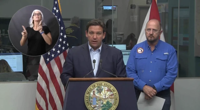
    Speaking alongside the governor, Florida Division of Emergency Management Director Kevin Guthrie asked the public not to take out their own boats to attempt to rescue stranded neighbours.

    He said the risk was still too high for untrained Floridians to set out on the water on their own.

    Governor Ron DeSantis added that the informal volunteer group known as the Cajun Navy was currently en route to Florida to help with rescue-and-recovery operations.

    "Those are some really battle-hardened folks," he said, noting their experience tackling flooding in Louisiana.

    "We really welcome them to the state of Florida," DeSantis said, adding: "There's going to be a lot of need to get into these communities in south-west Florida."

  2. Florida ready for massive waterborne rescuepublished at 23:04 British Summer Time 28 September 2022

    DeSantis at a briefingImage source, Reuters

    Florida Governor Ron DeSantis says that emergency officials, including 7,000 National Guard troops, are preparing to lead rescue operations into flood zones once the immediate danger of the storm passes.

    Inland counties, including ones that are over 100 miles from the coast, have also called for evacuations due to storm surge flooding

    At a news conference in the city of Tallahassee, DeSantis said that the state currently has available almost 250 aircrafts, 1,600 high water vehicles and 300 boats.

    "With water this high, these operations might need to be waterborne operations," he said, noting that central Naples had flooded.

    Rescuers, he said, "are prepared for a lot of different eventualities".

    The Republican governor also thanked other US states for sending resources to Florida to help in its preparations and recovery.

  3. Florida being 'battered' by stormpublished at 22:48 British Summer Time 28 September 2022

    In a news briefing, Florida Governor Ron DeSantis has just said the hurricane is causing structural damage in south-west Florida.

    He said Ian has battered the region, but that storm surge waters appear to have peaked already.

    He added that emergency 911 calls in three counties are being diverted to other regions as their phone connections are down.

    He added that people who chose not to leave, despite being in the high risk Zone A coastal regions, might not be rescued until the storm has fully passed.

  4. Flights grounded across the regionpublished at 22:27 British Summer Time 28 September 2022

    Planes grounded at Tampa International AirportImage source, Getty Images
    Image caption,

    Planes grounded at Tampa International Airport

    There have been more than 2,140 flight cancellations within, into or out of the US today, according to the website Flightaware, external.

    Several airports in Florida have closed in anticipation of Hurricane Ian, disrupting travel for many passengers. These include:

    • Melbourne Orlando International Airport
    • Orlando International Airport
    • Sarasota Bradenton International Airport
    • Southwest Florida International Airport
    • St Pete-Clearwater International Airport
    • Tampa International Airport

    The worst-affected airports in Florida are Orlando with 386 cancellations, Miami at 216 flights called off and Tampa which has 178 planes grounded.

    More than 3,500 flights have also been cancelled for Wednesday and Thursday in the US.

    Major airlines are waiving fees for affected travellers.

  5. Vacations extended for cruise ships as ports closepublished at 22:12 British Summer Time 28 September 2022

    Carnival ParadiseImage source, Getty Images
    Image caption,

    The Carnival Paradise during a previous voyage

    Five cruise ships carrying thousands of passengers have reportedly had their trips extended or re-routed amid port closures caused by Hurricane Ian.

    Three of Florida's busiest ports - Port Tampa Bay, Port Canaveral and Jackson Port Authority - have been closed as Ian pounds Florida.

    Among the ships is the Carnival Paradise, which was originally due to return to Port Tampa Bay this week, but instead docked overnight in Cozumel, Mexico.

    Matt Lupoli, a spokesman for Carnival Cruise Line, was quoted by the Tampa Bay Times as saying that the ship would depart Cozumel later on Wednesday and head to Tampa, but would remain "a safe distance" from the storm.

    Carnival Elation, which left Jacksonville on Saturday, has changed its route and will remain at sea until the port reopens, according to CBS.

    Three other ships - Royal Caribbean's Manner of the Seas, Norwegian Getaway and MSC Divina - were all due back in ports on Thursday, but will reportedly remain at sea for longer than anticipated.

  6. A million Floridians without powerpublished at 21:56 British Summer Time 28 September 2022

    Blowing trees in FloridaImage source, Getty Images

    Over one millions Floridians are currently without electricity, according to tracker PowerOutages.us.

    As of right now, some 1,079,004 Florida residents and businesses have no power, according to the website.

    In four of the affected Florida counties, over 60% of customers have lost power.

    Officials have warned of power outages due to downed power lines, and caution that the blackouts will continue until recovery operations can begin after the hurricane passes.

  7. In pictures: Hurricane Ianpublished at 21:36 British Summer Time 28 September 2022

    Road littered and pummelled with rain amid heavy hurricane winds.Image source, Getty Images
    Image caption,

    Debris litters a street in St Petersburg, Florida

    Man captures heavy wind and flying debris on his phone in Sarasota Bay, FloridaImage source, Getty Images
    Image caption,

    A man is buffeted by strong winds hitting Sarasota Bay

    A tree is knocked down by powerful wind from Hurricane IanImage source, Reuters
    Image caption,

    Wind knocked down small trees in a hotel car park in Sarasota

    A sail boat at Sarasota Bay amid powerful hurricane windImage source, Getty Images
    Image caption,

    A sail boat is beached at Sarasota Bay

    Sign near St PetersburgImage source, Getty Images
    Image caption,

    A road sign toppled near St Petersburg

    Woman and dog in St PetersburgImage source, Getty Images
    Image caption,

    A woman walks her dog in St Petersburg as Ian approaches

    Man on phone in stormImage source, Getty Images
    Image caption,

    A man livestreams as the storm approaches the Florida town of Punta Gorda

  8. Parts of Marco Island underwaterpublished at 21:21 British Summer Time 28 September 2022

    Police in Marco Island said the storm had already dumped about 2.5ft (76cm) of water in parts of the town.

    Marco Island is a barrier island in south-west Florida, connected by bridges to the city of Naples on the mainland.

    This Twitter post cannot be displayed in your browser. Please enable Javascript or try a different browser.View original content on Twitter
    The BBC is not responsible for the content of external sites.
    Skip twitter post

    Allow Twitter content?

    This article contains content provided by Twitter. We ask for your permission before anything is loaded, as they may be using cookies and other technologies. You may want to read Twitter’s cookie policy, external and privacy policy, external before accepting. To view this content choose ‘accept and continue’.

    The BBC is not responsible for the content of external sites.
    End of twitter post
  9. Hurricane v typhoon - what's the difference?published at 21:10 British Summer Time 28 September 2022

    Those who live in the Northwest Pacific - near the coast of Vietnam, the Philippines and Taiwan - might be more familiar with the term typhoon to describe an intense tropical storm.

    Typhoons and hurricanes are essentially the same thing - both feature a rotating system of clouds and thunderstorms that is spawned over tropical waters.

    The only difference between the two is where they happen.

    The term hurricane refers to tropical cyclones that occur in the North Atlantic Ocean and central and eastern North Pacific Ocean.

    Typhoons, on the other hand, are what we call tropical cyclones that occur in the Northwest Pacific.

  10. More than 20 Cuban migrants missing off Florida coastpublished at 20:56 British Summer Time 28 September 2022

    The US Border Patrol and Coast Guard are looking for more than 20 missing migrants after their ship sank during the storm.

    Walter Slosar, Border Patrol Miami's chief patrol officer, said his officers had been alerted alongside local police to a landing of four migrants in Stock Island.

    In a tweet, external, he said the four had "swam to shore after their vessel sank due to inclement weather".

    The discovery prompted the launch of a search-and-rescue operation to find another 23 people believed to have been on board.

    On Tuesday, seven Cuban migrants were taken into custody after reaching the US mainland at nearby Pompano Beach.

    "Do not risk your life by attempting this journey at sea," Slosar said in a separate tweet.

    This Twitter post cannot be displayed in your browser. Please enable Javascript or try a different browser.View original content on Twitter
    The BBC is not responsible for the content of external sites.
    Skip twitter post

    Allow Twitter content?

    This article contains content provided by Twitter. We ask for your permission before anything is loaded, as they may be using cookies and other technologies. You may want to read Twitter’s cookie policy, external and privacy policy, external before accepting. To view this content choose ‘accept and continue’.

    The BBC is not responsible for the content of external sites.
    End of twitter post
  11. Here's what the eye of the hurricane looks likepublished at 20:28 British Summer Time 28 September 2022

    Satellite imagery released by the National Oceanic and Atmospheric Administration (NOAA) shows repeated flashes of lightning around the eye of the storm as Hurricane Ian strengthened over the Gulf of Mexico.

    Ian has just made landfall on the southwestern Florida coast.

    Media caption,

    Hundreds of lightning strikes as Hurricane Ian nears Florida

  12. Where is Hurricane Ian heading?published at 20:22 British Summer Time 28 September 2022

    Map showing Hurricane Ian hitting Florida's coast on 14:00 Wednesday before making its way up.
  13. Hurricane Ian makes landfall in south-western Floridapublished at 20:18 British Summer Time 28 September 2022
    Breaking

    The National Hurricane Center says Hurricane Ian has officially made landfall in south-western Florida as an "extremely dangerous" category four hurricane at 15:10 local time (20:10 GMT).

  14. The situation in Miami Beachpublished at 20:02 British Summer Time 28 September 2022

    Rafael Abuchaibe
    Reporting from Miami Beach

    Miami Beach

    Some curious locals and visitors in the touristy South Beach paid little attention to the warnings of tropical storm conditions caused by the passing of Hurricane Ian, which as of now - as it nears landfall near the central Florida city of Tampa - remains a category 4 storm.

    Despite being fairly distant from the storm’s main path, the three most populous counties in Florida - Miami-Dade, Broward and Palm Beach - are feeling the effects of the powerful winds, which last night translated in tornadoes that affected the city of West Miami Dade and a local airport in Broward.

    Photographs that circulated on social media showed that the tornado that passed over North Perry Airport, in Pembroke Pines, west of Fort Lauderdale on Tuesday night, had destroyed several single-engine aircrafts in its path.

    There were no reports of injuries or fatalities, and according to Florida Power and Light (FPL), the state’s power company, little over 18.000 users had no electricity in Miami-Dade, almost 8.000 in Broward and 5.200 in Palm Beach.

    Ian also led local authorities in Miami-Dade and Broward counties to announce the closure of schools and "non-essential" services such as libraries and parks throughout Wednesday and Thursday.

    Miami Beach
  15. Hotel guests hold door shut as Hurricane Ian rages outsidepublished at 19:41 British Summer Time 28 September 2022

  16. What does the hurricane look like from above?published at 19:34 British Summer Time 28 September 2022

    Hurricane Ian moves toward Florida on September 28Image source, NOAA/Getty
    Image caption,

    Hurricane Ian is moving towards Florida in the Gulf of Mexico, images from today show

    There is a lot of focus on the ground about the impact Hurricane Ian has had in Cuba and is expected to make throughout Florida - but what is the view from above?

    The National Oceanic and Atmospheric Administration (NOAA) Aircraft Operations Center has shared some of its satellite images showing the hurricane's progress over the last few days.

    Satelite image of Hurricane IanImage source, NOAA
    Image caption,

    Satellite images are used to track the hurricane

    Hurricane Ian enters the Gulf of MexicoImage source, NASA/Getty
    Image caption,

    Hurricane Ian entered the Gulf of Mexico on Tuesday after hitting Cuba and leaving it without electricity

    A satellite image as Hurricane Ian moved towards Western Cuba on 26 SeptemberImage source, NOAA/Getty
    Image caption,

    Footage from 26 September showed Hurricane Ian moving towards western Cuba

  17. Ian brings tornado risk to Orlando and surrounding areaspublished at 19:22 British Summer Time 28 September 2022

    As areas on Florida's western coast feel the direct impact of Hurricane Ian, regions outside of the storm's direct path are bracing for possible tornadoes.

    A tornado watch has been issued by the US National Weather Service until 17:00 local time (22:00 GMT) for a large area in east central Florida.

    There is an enhanced risk in particular of tornadoes hitting Daytona Beach, Orlando and West Palm Beach on the eastern side of the peninsula.

    This Twitter post cannot be displayed in your browser. Please enable Javascript or try a different browser.View original content on Twitter
    The BBC is not responsible for the content of external sites.
    Skip twitter post

    Allow Twitter content?

    This article contains content provided by Twitter. We ask for your permission before anything is loaded, as they may be using cookies and other technologies. You may want to read Twitter’s cookie policy, external and privacy policy, external before accepting. To view this content choose ‘accept and continue’.

    The BBC is not responsible for the content of external sites.
    End of twitter post
  18. Florida governor says Hurricane Ian has made landfallpublished at 19:07 British Summer Time 28 September 2022

    Governor Ron DeSantis has tweeted that the hurricane is making landfall now, though the National Hurricane Center's 14:00 local time update says it will make landfall "soon".

    The hurricane has been battering Florida's coastline for hours, with the eyewall of the storm reaching the coast just over an hour ago.

    This Twitter post cannot be displayed in your browser. Please enable Javascript or try a different browser.View original content on Twitter
    The BBC is not responsible for the content of external sites.
    Skip twitter post

    Allow Twitter content?

    This article contains content provided by Twitter. We ask for your permission before anything is loaded, as they may be using cookies and other technologies. You may want to read Twitter’s cookie policy, external and privacy policy, external before accepting. To view this content choose ‘accept and continue’.

    The BBC is not responsible for the content of external sites.
    End of twitter post
    This Twitter post cannot be displayed in your browser. Please enable Javascript or try a different browser.View original content on Twitter
    The BBC is not responsible for the content of external sites.
    Skip twitter post 2

    Allow Twitter content?

    This article contains content provided by Twitter. We ask for your permission before anything is loaded, as they may be using cookies and other technologies. You may want to read Twitter’s cookie policy, external and privacy policy, external before accepting. To view this content choose ‘accept and continue’.

    The BBC is not responsible for the content of external sites.
    End of twitter post 2
  19. If you're just joining us, here is the latestpublished at 19:01 British Summer Time 28 September 2022

    It's time for our top of the hour update. Here's the latest on the storm.

    • Hurricane Ian has hit Florida's coast on Sanibel and Captiva Islands, causing a dramatic storm surge in the area, which is under an evacuation order
    • The hurricane is now about 35 miles (80 km) southwest of Fort Myers
    • The US National Weather Service has issued an extreme wind warning for Englewood, Rotonda and Grove City, near where the eyewall has moved onshore, until 14:00 local time (18:00 GMT)
    • Nearly 300,000 people in Florida are now without power
    • Officials say at least 15 hospitals and 40 nursing homes have been evacuated
    • A flood warning is also in effect for east central Florida until 16:00 local time
    • Ian's maximum sustained wind speed remains at a high 155 mph (250 kmh)
  20. 'Big time surge' at Pine Island on Gulf Coastpublished at 18:44 British Summer Time 28 September 2022

    US meteorologist Reed Timmer has been sharing pictures from Pine Island - an island off of Florida's Gulf Coast which is under a mandatory evacuation order.

    Timmer said the eye of the storm will bring powerful winds and storm surge of up to 15 feet to the area.

    He said Ian, now a Category 4 storm, is rapidly approaching Category 5 intensity.

    As Hurricane Ian moves further into Florida, forecasters are predicting an "absolutely catastrophic" storm surge in cities like Fort Myers and Punta Gorda.

    This Twitter post cannot be displayed in your browser. Please enable Javascript or try a different browser.View original content on Twitter
    The BBC is not responsible for the content of external sites.
    Skip twitter post

    Allow Twitter content?

    This article contains content provided by Twitter. We ask for your permission before anything is loaded, as they may be using cookies and other technologies. You may want to read Twitter’s cookie policy, external and privacy policy, external before accepting. To view this content choose ‘accept and continue’.

    The BBC is not responsible for the content of external sites.
    End of twitter post