Summary

  • Hurricane Ian made landfall for a second time in the US after devastating Florida - hitting South Carolina's coast

  • Forecasters predicted a storm surge and floods, with the historic city of Charleston likely to feel the brunt of the storm

  • It was downgraded from a category one hurricane to a post-tropical cyclone, and was expected to weaken further overnight

  • President Joe Biden approved an emergency declaration for the state, meaning recovery funds can be sent more quickly once the hurricane passes

  • Ian first made landfall in Florida on Wednesday near the city of Fort Myers and brought flooding, high winds and storm surges 

  • At least 21 people may have died in the state, officials say, but exact casualty figures are still being determined

  • More than 2.6 million Florida homes and businesses have no electricity and some areas have been left submerged

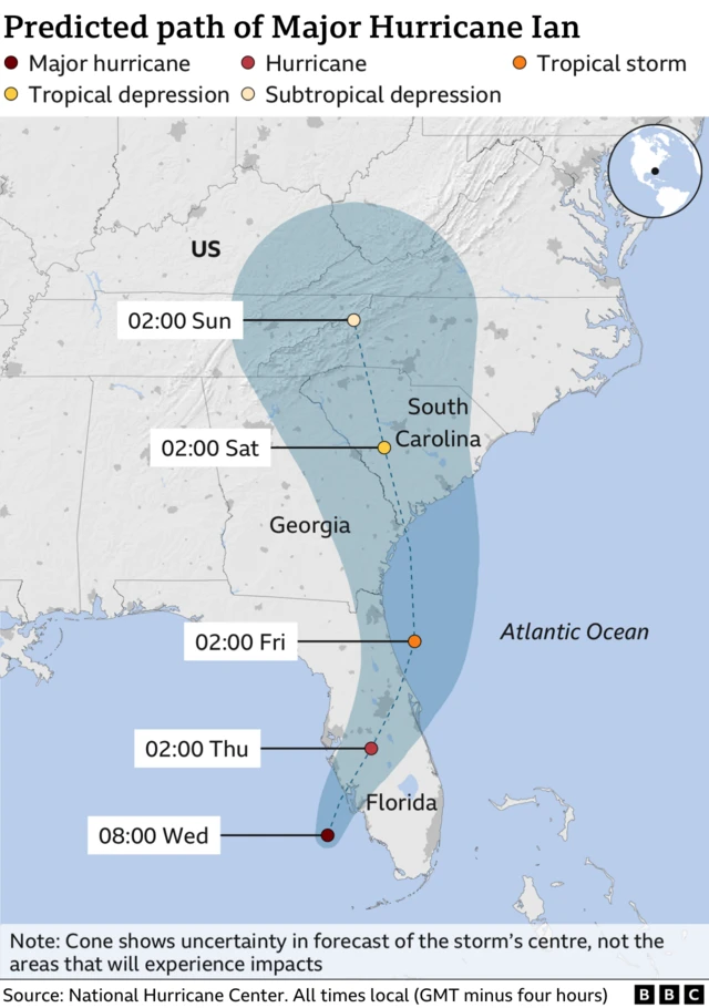
  1. Florida governor warns of long path aheadpublished at 18:33 British Summer Time 28 September 2022

    An empty road in Ybor City, FloridaImage source, Getty Images

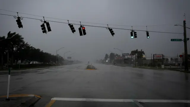
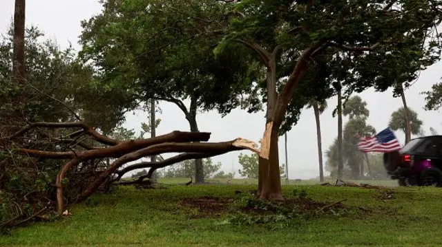
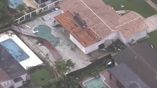
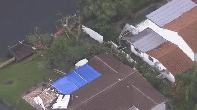
    Florida Governor Ron DeSantis says roughly 200,000 power outages have now been reported across the state - with some estimating far higher.

    That number is "a drop in the bucket for what is going to happen in the next 24 to 48 hours," he said at a Wednesday afternoon briefing.

    Portable cell towers would be put in place in affected areas once safe, he said.

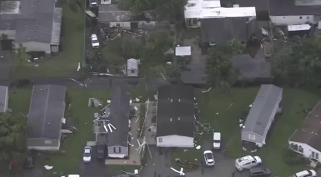
    The governor said that more than 30 helicopters, including from neighbouring states, stand ready to assist with search and rescue operations.

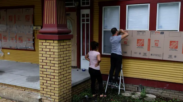
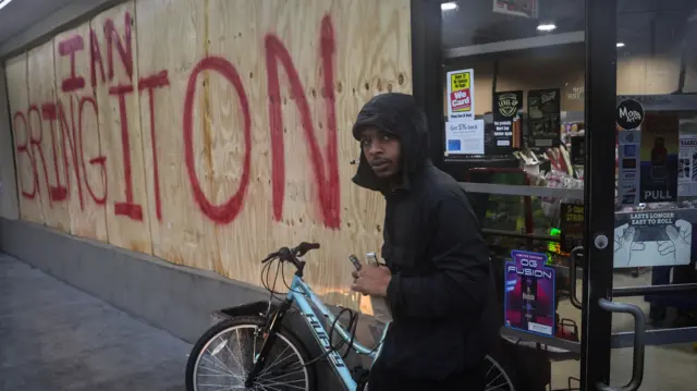
    "Most people did leave but there's a small group of people that decided to hunker down," DeSantis noted.

    He urged residents who are sheltering-in-place in the southwest region of the state to not go outside, as debris and even large objects like vehicles could be tossed into the air.

    "Even if it's calm outside, you may just be in the eye of the storm. Stay inside, stay indoors," Kevin Guthrie, his top emergency management official said.

  2. Ian leaves many Cubans in complete darknesspublished at 18:15 British Summer Time 28 September 2022

    Will Grant
    BBC Central America correspondent

    A woman stands on a flooded street in Havana on WednesdayImage source, Getty Images
    Image caption,

    A woman stands on a flooded street in Havana on Wednesday

    Photographs posted by Cubans online show their cities in complete darkness, with just flickers of light in the distance.

    However, such images belie a much tougher and exhausting reality from end to end of the island.

    The areas where the electricity was initially knocked out by Hurricane Ian - westward side of the island and parts of Havana - have now experienced well over 24 hours without light.

    They were joined by the rest of the island at around 6pm local time on Tuesday.

    The blackout means that water in many areas is unavailable too. Anywhere which relies on pumping water to the taps is currently dry. No bathing and no boiling water to drink.

    It also means no working fridges and freezers in people’s homes, and food is turning bad already. In a country with such scarcity of basic good, where people tend to stockpile frozen chicken and meat and cheese and other items when they appear in the shops, this amounts to a huge loss for millions of families.

    Residents are still reeling from the huge explosions at the island’s biggest fuel depot in Matanzas last month, which deprived Cuba of at least half of its storage capacity and began a series of rolling blackouts. This, now exacerbated by this latest disaster.

    The worst affected are those who lay directly in Hurricane Ian’s path. The trail of destruction left behind includes homes with roofs torn off, trees and power lines down, vital crops ruined and flooding.

    When the government described the situation as “complex”, most Cubans take that to mean weeks, rather than days, before normality is restored.

  3. Residents ride out the storm at a St. Petersburg high schoolpublished at 17:59 British Summer Time 28 September 2022

    Photo of Tommy Sr. and Tommy Jr.
    Image caption,

    Tommy Sr. and Tommy Jr. are currently staying at the shelter.

    More now on the ground from a shelter in St. Petersburg, Florida, where BBC reporters visited earlier today.

    People living in evacuation zones and high-risk areas are riding out the storm on higher ground at Gibbs High School. The shelter has welcomed 541 people since opening on Tuesday - way more than they were anticipating.

    The shelter is providing meals and a safe place to stay for locals including the unhoused and those with special needs.

    On Wednesday morning, a father and son - Tommy Sr. and Tommy Jr. - sat outside the shelter watching as rain battered the parking lot in front of the high school.

    "I'm pretty certain it's gonna be damaged.” Tommy Sr. said, pondering the fate of the family’s home. “I’m worried about after. If it gets hammered, I don't know where we're gonna go then."

    The shelter also houses dogs and cats. Pets are often an important consideration when people are deciding whether or not to evacuate.

    Employees from Pinellas County animal services have been at the shelter full-time since Tuesday, staying overnight to help register animals and make sure they are taken care of.

    They currently have 31 dogs and 22 cats. “It’s more than it sounds,” Caitlyn Harrison said.

    The storm can be difficult for the animals who must be kept in crates and are not allowed outside during the storm.

    “It can be hard for the dogs for sure,” Harrison said. But pet owners are allowed to visit with their animals any time of day. For many, knowing their animals are safe is the priority as Ian continues to threaten the area.

  4. Hurricane Ian hits coastpublished at 17:53 British Summer Time 28 September 2022

    The eye of Hurricane Ian has hit the coast of Florida - and the National Weather Service has reiterated its warning for extreme winds.

    It is urging anyone in impacted areas to find shelter "immediately".

    Extreme hurricane winds are either "imminent or happening NOW", it said - saying sustained winds of 115 mph (185 kmh) are expected.

    This Twitter post cannot be displayed in your browser. Please enable Javascript or try a different browser.View original content on Twitter
    The BBC is not responsible for the content of external sites.
    Skip twitter post

    Allow Twitter content?

    This article contains content provided by Twitter. We ask for your permission before anything is loaded, as they may be using cookies and other technologies. You may want to read Twitter’s cookie policy, external and privacy policy, external before accepting. To view this content choose ‘accept and continue’.

    The BBC is not responsible for the content of external sites.
    End of twitter post
  5. Why is Hurricane Ian so dangerous?published at 17:50 British Summer Time 28 September 2022

    BBC Weather

    With the National Hurricane Center previously saying Ian was "rapidly intensifying", BBC Weather has been assessing why it is considered so dangerous:

    • Developing over the warm waters of the Gulf of Mexico means it has intensified to a major hurricane
    • It is expected to "slow to a walking pace" as it approaches Florida, resulting in heavy rain and winds lasting longer
    • As it travels up the coast of Florida, more water is pushed onshore, equating to a life-threatening storm surge

    See more here.

  6. In pictures: Hurricane Ian approachespublished at 17:37 British Summer Time 28 September 2022

    Traffic lights wave by strong gust of wind ahead of Hurricane Ian, in Fort Myers, Florida,Image source, Reuters
    Image caption,

    Traffic lights sway in a strong gust of wind and the sky looks dark in Fort Myers, Florida

    People attempt to weather proof a home with cardboard in Tampa, FloridaImage source, Reuters
    Image caption,

    People attempt to weatherproof a home with cardboard in Tampa, Florida

    A tree is torn in half in Sarasota, FloridaImage source, Getty Images
    Image caption,

    A tree is torn in half in Sarasota

    A convenience store in TampaImage source, Getty Images
    Image caption,

    A convenience store in Tampa carries a message for Ian

  7. Floridians put aside political differences in the face of a hurricanepublished at 17:31 British Summer Time 28 September 2022

    Alexandra Ostasiewicz
    BBC News, Florida

    Image shows Jean Fargo at a local shelter

    It was a tough decision for Jean Fargo to leave her home.

    “We were reluctant at first,” she said. The St Petersburg resident has been through storms before “but this one is different”.

    After learning more about the dangers of storm surge, she decided to evacuate to the shelter at a local high school. “We've been really pleasantly surprised by shelter conditions," she said.

    Not only is the food good, but she is also feeling a sense of community and camaraderie among those in the shelter.

    “We’ve made friends with the people next to us. They have different political stripes, but we all agree that this disaster doesn’t involve politics at all,” she said.

    In a state that has been polarised along political fault lines in recent months, banding together in the face of a natural disaster is a shift in narrative for many.

    While sharing blankets with her new neighbours has provided Jean some reprieve from the stresses of the storm, she still faces real concerns about what Hurricane Ian will leave in its wake.

    “There’s a lot of worries,” she said. She has been hoping to sell her house, and even has a buyer lined up, but if it’s damaged they may be forced to stay and repair it. “I wouldn’t blame the buyer if they backed out."

    She'll have to wait and see, but is happy to be somewhere safe for now.

  8. Satellite images show early storm damagepublished at 17:23 British Summer Time 28 September 2022

    Homes battered by storm surge in FloridaImage source, CBS Miami
    Image caption,

    Houses have been battered by the storm surge

    Satellite images are starting to show homes that have already been damaged by the storm surge caused by Hurricane Ian.

    Fencing has been torn down, trees have fallen and houses have been battered.

    These pictures were taken this morning in Broward County, Florida, in the Miami area.

    Fences have been town downImage source, CBS Miami
    Image caption,

    Fences have been pulled down by the strong winds

    Trees have fallen down and rooves have been ripped offImage source, CBS Miami
    Image caption,

    Roofs have been ripped off and trees have been knocked down

  9. White House 'ready to help in every way possible'published at 17:14 British Summer Time 28 September 2022

    President Joe Biden has said he is closely monitoring developments about the hurricane and its expected impacts.

    Officials in Washington have been in touch since the weekend with the state's Governor Ron DeSantis - a major political rival to Biden - as well as local mayors.

    "I made it clear to the governor and the mayors that the federal government is ready to help in every single way possible," Biden said in brief remarks ahead of a White House hunger summit on Wednesday.

    He reiterated calls to heed the advice of local officials and to be prepared.

    "The danger is real," he said. "When the storm passes, we'll be there to help you clean up and rebuild to help get Florida get moving again. That's my absolute commitment."

    This Twitter post cannot be displayed in your browser. Please enable Javascript or try a different browser.View original content on Twitter
    The BBC is not responsible for the content of external sites.
    Skip twitter post

    Allow Twitter content?

    This article contains content provided by Twitter. We ask for your permission before anything is loaded, as they may be using cookies and other technologies. You may want to read Twitter’s cookie policy, external and privacy policy, external before accepting. To view this content choose ‘accept and continue’.

    The BBC is not responsible for the content of external sites.
    End of twitter post
  10. The latest from Floridapublished at 17:00 British Summer Time 28 September 2022

    • The eyewall of Hurricane Ian is moving onshore to Florida's western coast. It is expected to bring destructive waves along Englewood to Bonita Beach
    • The US National Hurricane Center says the catastrophic storm surge in the area will hit 12 to 18ft above ground level
    • Catastrophic wind damage is also expected. The latest reported maximum sustained wind speed of Ian is 155 mph (250 kmh), making it a strong Category 4 storm
    • Ian is expected to maintain its intensity as it crosses Florida
    • The storm will bring heavy rainfall across the Florida peninsula through Thursday, with warnings of life-threatening catastrophic flooding in parts of central Florida
    • Heavy rainfall is expected to reach parts of the south-east US later this week

  11. Anxiety builds as Tampa Bay braces for Ianpublished at 16:46 British Summer Time 28 September 2022

    Alexandra Ostasiewicz
    BBC News, Florida

    People walk along the shore of Tampa Bay's Bayshore Boulevard on Wednesday morningImage source, Getty Images

    In the Tampa Bay area, locals are no strangers to hurricane warnings, but even the most seasoned are taking this storm seriously.

    The energy in the city changed overnight as residents woke to pounding rain and choppy water in the normally tranquil bay.

    As the day wears on and the wind gusts intensify, the anxiety is increasing.

    Roads are empty of vehicles, but starting to fill up with water and debris blown from palm trees.

    Shops are all shuttered except for some petrol stations, but even those are all out of fuel.

    With the window to evacuate closing, everyone is hunkering down to wait out the storm and hope for the best.

  12. What does a Category 4 storm mean?published at 16:31 British Summer Time 28 September 2022

    Hurricanes are measured using the Saffir-Simpson hurricane wind scale on a 1 to 5 rating.

    Categories 3 to 5 are considered a major hurricane. At the moment, Ian is projected to be just shy of a Category 5 hurricane.

    Where a hurricane lands on the scale depends on its maximum sustained windspeed.

    Here's what each category means:

    • Category 1: Sustained wind speed of 79 to 95 mph (119 to 153 kmh). It is powerful enough to damage roofs, shingles and large branches of trees
    • Category 2: Sustained wind speed of 96 to 110 mph (154 to 177 kmh). Homes could suffer major roof damage, and near-total power loss is likely to last days
    • Category 3: Sustained wind speed of 111 to 129 mph (178 to 208 kmh). Damage is devastating, and access to both electricity and water is impacted
    • Category 4: Sustained wind speed of 130 to 156 mph (209 to 251 kmh). Damage is catastrophic, with severe impact on roofs and exterior walls of homes. Some areas may become uninhabitable for weeks or months
    • Category 5: Sustained wind speed of 157 mph (252 kmh) or higher. Many homes may be destroyed, with roof and wall collapse. Power outages can last weeks or months, and most of the area hit will be uninhabitable for a long time

  13. Wind speeds of 250 kmh (155 mph) forecastpublished at 16:31 British Summer Time 28 September 2022

    BBC Weather

    As Hurricane Ian continues closes in on Florida, the forecasted intensity has been raised to 250 kmh (155 mph) at landfall.

    It is a Category 4 storm, but the forecasted wind speeds are close to level 5 which equates to winds measuring 252 kmh (157mph) or higher.

    A catastrophic storm surge of 12 to 16ft (3.7 to 1.9m) from Englewood to Bonita Beach in Florida is also expected.

    A map showing the forecasted impact of Hurricane IanImage source, NOAA
    Image caption,

    The forecast shows Charlotte Harbour is expected to feel the brunt of Hurricane Ian

  14. Hurricane Ian eyewall moves onshorepublished at 16:17 British Summer Time 28 September 2022

    The National Hurricane Center says the eyewall of Hurricane Ian is now starting to move onshore.

    The storm will cause "catastrophic storm surge, winds and flooding" in to areas in its path soon, they added.

    This Twitter post cannot be displayed in your browser. Please enable Javascript or try a different browser.View original content on Twitter
    The BBC is not responsible for the content of external sites.
    Skip twitter post

    Allow Twitter content?

    This article contains content provided by Twitter. We ask for your permission before anything is loaded, as they may be using cookies and other technologies. You may want to read Twitter’s cookie policy, external and privacy policy, external before accepting. To view this content choose ‘accept and continue’.

    The BBC is not responsible for the content of external sites.
    End of twitter post
  15. When will Hurricane Ian make landfall?published at 16:06 British Summer Time 28 September 2022

    Graphic showing path of Hurricane Ian

    As of 10:00 local time (14:00 GMT), Ian appears to be about 60 miles (95 km) west of Naples and 65 miles south-west of Punta Gorda, Florida.

    The US National Hurricane Center forecasts its maximum sustained wind speed at 155 mph (250 kmh).

    It is still projected that Ian will reach Florida's western coastline some time in the afternoon.

  16. Older population in impacted areas 'a concern'published at 15:56 British Summer Time 28 September 2022

    An evacuation sign in Punta Gorda, FloridaImage source, Reuters
    Image caption,

    Evacuation signs have been put up - including in Punta Gorda, Florida

    Evacuation orders continue to be issued but officials say it may be too late to evacuate some residents who have not yet left.

    Deanne Criswell, administrator of the US disaster agency FEMA, notes she is concerned about a significant population of Floridians over the age of 60 in areas likely to be impacted by the hurricane.

    "Stay in place," she says at her Wednesday morning briefing. "Don't go out there."

    Forecasters currently predict the hurricane is about 60 miles west of the city of Naples, and about 65 miles southwest of Punta Gorda.

    Naples is a hot spot for retirees and "snow birds" - the Americans who move to Florida in the winter months - while Punta Gorda is also a very popular tourist destination.

  17. 'Nerve-racking': Florida residents brace for hurricanepublished at 15:42 British Summer Time 28 September 2022

    St. Petersburg public marina is one of many areas under an evacuation order. Here's how residents are feeling as they await the storm:

  18. Shelters in place as Hurricane Ian approachespublished at 15:24 British Summer Time 28 September 2022

    A man brings children to a shelter for evacuees ahead of Hurricane Ian at Lockhart Elementary school in Tampa, Florida, U.S., September 28, 2022. REUTERS/Shannon StapletonImage source, Reuters
    Image caption,

    A man brings children to a shelter for evacuees at Lockhart Elementary school in Tampa

    As Florida counties in the path of the storm issue shelter-in-place orders, the Red Cross has sent hundreds of volunteers and thousands of relief supplies to Florida.

    It has also opened dozens of shelters for people to ride out the storm. Shelter locations can be found at redcross.org, external or by calling 1-800-RED CROSS (1-800-733-2767). They can also be found at floridadisaster.org., external

    The US Federal Emergency Management Agency, known as FEMA, has staged land, air and sea search and rescue teams in Miami to assist as the hurricane hits.

    Nearly four million meals and 3.5 million litres of water have also been prepared for those who are in need.

    A list of evacuation orders for Florida can be found here., external

  19. Water is dangerous so do not wade in - US disaster agencypublished at 15:12 British Summer Time 28 September 2022

    Federal Emergency Management Agency administrator Deanne Criswell is warning residents that coastal areas can expect powerful storm surges, while inland areas can also expect flooding.

    "Water is dangerous," she notes, saying people should evacuate rather than wade into affected areas.

    She warns not to drive through standing or moving water, because vehicles can be swept away in the current.

    She calls on Floridians to heed the warning of local officials before, during and after the storm.

    Ninety percent of fatalities during hurricanes come from water, Ken Graham, the head of the National Weather Service says later.

    "The water is going to be incredibly dangerous."

  20. Briefing on Hurricane Ian beginspublished at 15:02 British Summer Time 28 September 2022

    Officials from the US disaster agency the Federal Emergency Management Agency (FEMA) are briefing the public on Hurricane Ian.

    FEMA helps Americans prepare for, respond to and recover from natural disasters.

    It has pre-positioned hundreds of first responders, and millions of meals and litres of water in at least two states in preparation for Ian.