Mapping Earth's surface in 3D
- Published
- comments

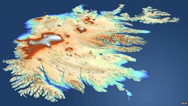
TanDEM's view of Iceland: The country was beyond the sight of the shuttle topography mission in 2000
The German satellite radar twins - TanDEM-X and TerraSAR-X, external - are a year through their quest to make the most precise, seamless map of varying height on Earth.
They've now acquired data across the entire globe at least once. However, some tricky sampling areas, such as tall mountains and thick forests, will require several passes and so we don't expect to see a fully finished product before 2014.
The Digital Elevation Model, or DEM, has become one of those must-have technical tools.
Planners use them to work out where best to put new buildings, roads and railways; airline pilots need the information to fly planes safely; telecos look at DEMs before siting their transmitters; and generals feed the data into autonomous weapons. Archaeologists, volcanologists, glaciologists, hydrologists, ecologists - they all want to know the shape of the Earth's surface. Even a games developer wanting to produce ever more realistic landscapes will have reason to resort to a DEM.
Space shuttle Endeavour famously made a world DEM in 2000. It hung a radar system out of its payload bay and mapped about 80% of the Earth's land surface.
I've heard it said that this is the most used Earth observation dataset in history. Someone can put us right on that if it's wrong, but the popularity of the shuttle's 3D map of the Earth doesn't surprise me.
And it explains why the German space agency (DLR) and Europe's biggest space company, Astrium, are now trying to produce a more detailed and a more extensive version a decade on.
The Shuttle Radar Topography Mission (SRTM), external product has a best spatial resolution of 30m by 30m, and a vertical resolution that varies from 16m to 10m.

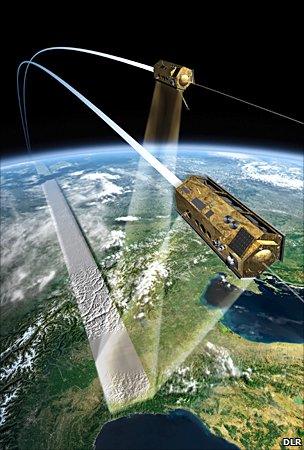
The satellites trace a helix across the sky as they move just 150m apart
The intention of the TanDEM mission, external is to go down to a spatial resolution of 12m by 12m and a vertical resolution of two metres.
"The two metres is what we call the relative accuracy," explained Dr Manfred Zink, the project manager for the TanDEM-X ground segment at DLR. "It means if you take an area one degree by one degree, latitude by longitude, which at the equator is roughly 100km by 100km, you can take any two points in the DEM and the error between the two points is less than two metres," he told me. "In absolute terms, each and every single point has to be better than 10m."
Airbone lidars can achieve much better precision, but these maps are necessarily regional in extent - they will cover only relatively small areas. The purpose of TanDEM is to build a world DEM that is single-source and has "no joins".
Of course, what I find fascinating about the TanDEM mission is the way that data is being acquired.
The pair's radars work by constantly bouncing microwave pulses off the ground and sea surface. By timing how long the signal takes to make the return trip, the instruments can determine differences in height. As they circle the Earth, so they build up their DEM. That much is obvious.
But TanDEM-X and TerraSAR-X do something a little more interesting.
Their slightly offset orbits bring them extremely close to each other - to a separation of just 150m, as of last week.
Think about that for a moment - 514km up, moving at 7km/s with a gap of 150m. It leaves simply no room for error.
This compact orbital dance gives the pair "stereo vision", by enabling them to operate an interferometric mode in which one spacecraft acts as a transmitter/receiver and the other as a second receiver. Varying the geometry allows the pair to discern better the signal they see from different types of surface.

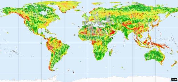
Earth is being mapped in strips. Some hard to see areas will need perhaps three or four more acquisitions
If you look at the map of acquisition, the colours tell you how well the TanDEM mission is progressing.
The green areas are where the two-metre requirement has already been met.
Yellow denotes those areas that will need at least a second acquisition. If you know your geography, you can see these include forested and desert locations like the Sahara which are not easy surfaces to read for radar.
Red areas are in most need of further acquisitions. You'll see these include the big mountain ranges.
"We always image a swath at an off-nadir angle of 30-40 degrees. In other words, we don't look straight down," said Dr Zink.
"So, if you see a tall mountain and you image it only from one side, there is going to be a slope on the farside that you cannot see. This applies to places such as the Alps, the Andes and the Himalayas where after one acquisition, we still do not yet have enough data. These are the gaps we have at the moment."
If you are wondering, the grey describes those areas where the data has been acquired but not yet processed.

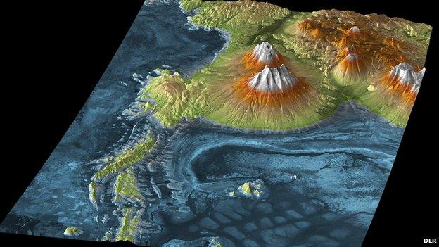
Salar de Uyuni: The largest salt flats (blue) in the world covering 10,000 sq km, located in southwest Bolivia
This is a monumental job. SRTM collected 8.6 terrabytes of data. TanDEM will collect 350 terrabytes of data in mapping the Earth's roughly 150 million square kilometres.
All the radar information has to be downlinked to ground stations, and in the case of the remote O'Higgins facility in Antarctica, the data is even put on tapes and physically carried back to Germany.
"The first coverage of the Earth is done and was very successful," says Dr Vark Helfritz from Astrium Geoinformation Services, external.
"The test data is really very promising and we believe we could potentially outperform the original specification.
"We need double coverage for the easier parts of the Earth's surface, and triple - and maybe even quadruple - for the more difficult parts.
"The mountains in northwest America and Norway - its water fjords - have been particularly challenging. But the hardware is working really well.
"I'm really looking forward to the first dual coverage because I think when you see that, you'll really notice a big difference."

The TanDEM Digital Elevation Model of Mount Etna, Sicily, Italy
- Published20 October 2010
- Published15 October 2010
- Published26 June 2010
- Published21 June 2010