UK scientists to probe Pine Island Glacier
- Published
Jonathan Amos explains how snow tractors, robot subs and seals with sensors will help study the glacier
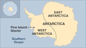
UK scientists are about to set out for Antarctica to investigate the mighty Pine Island Glacier.
The PIG drains about 10% of all the ice sliding off the west of the continent, and has seen a marked thinning and a surge in velocity in recent decades.
Its contribution to sea level rise is now greater than any other glacier on the planet.
The British Antarctic Survey-led team hopes its iStar project will provide new insights into the PIG's behaviour.
The researchers will gather their measurements using a diverse set of techniques and technologies, including robotic subs and satellites, and even instrument-carrying elephant seals.
"We want to improve our understanding of what this glacier is doing and to use that information to be able to make good predictions for its contribution to global sea level in the years ahead," said Dr Andy Smith, iStar's science programme manager at BAS.
"And if we can do that, if we can make those good predictions, then we'll also have some tools to apply to the rest of the Antarctic and the Greenland ice sheet as well," he told BBC News.
Dr Smith officially announced the venture on Monday at the British Science Association annual festival in Newcastle.
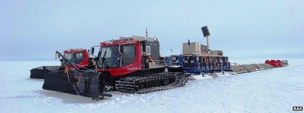
A traverse across the glacier by tractor will acquire a raft of new measurements
The PIG is vast. The glacier runs alongside the Hudson mountains into the Amundsen Sea, draining an area covering more than 160,000 sq km - about two-thirds the size of the UK. And it can produce colossal icebergs, such as the 720-sq-km "ice island" that broke off into the ocean in July.
Dr Andy Smith: It's one of the remotest places in West Antarctica
But the PIG's remoteness has made it difficult to study, and it is only in the past 20 years or so, with the aid of satellites, that scientists have realised the glacier is undergoing significant change.
Space data indicates the rate at which it is losing mass is doubling about every five years.
This acceleration has been attributed in part to warmer ocean waters getting under and melting the PIG's ice shelf - the long floating tongue that protrudes out into Amundsen Bay. The grounding line - the point where this shelf starts to become buoyant - has pulled back further and further towards the land.
The iStar project has two major expeditions this Antarctic summer to try to probe more keenly how the warming of the ocean is coupling to the drawdown of ice deep inland.
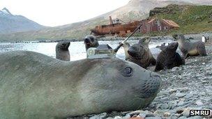
Small oceanographic sensors attached to the seals' fur fall off after a few months
The first mission, starting in November, is a 10-week, 1,000km traverse by tractor across the top of the glacier. One of its tasks will be to map the rockbed beneath Pine Island Glacier. Much of the traverse data is expected to feed back into the validation of future space monitoring, says Dr Andy Shepherd of Leeds University.
"We need field measurements to beat down the remaining uncertainties in the satellite data," he told the BBC.
"There will be ground measurements that help us understand how much rock uplift there is beneath the ice; how much compaction of snow there is at the surface of the glacier; and indeed how much variability there is in the snowfall from year to year.
"All of these factors can complicate the signal and we want to iron them out so that scientists can see that the satellite numbers are robust and can be trusted."
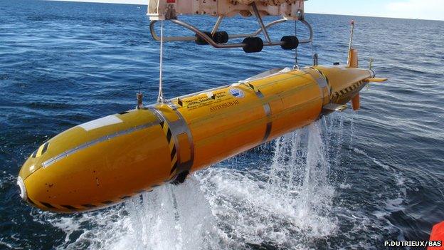
The nearly three-tonne Autosub operates on its own for up to 30 hours
In January, iStar's oceanographers are expected to arrive in the Amundsen Sea onboard the RRS James Clark Ross.
They will be putting a fleet of ocean robots known as Seagliders into the water. These vehicles measure temperature, salinity and current behaviour at different depths. The gliders will operate in front of the ice shelf. The ship will, however, release its big unmanned submarine, Autosub, to go under the shelf.
This 7m-long probe will map the cavity and the geometry of a ridge on the seabed that appears to play a key role in limiting the ingress of warm water from the ocean.
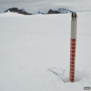
BAS has new technologies, such as air-dropped GPS stations, to monitor glacier flow
"We want to look in more detail at the processes that control the exchange of waters over this ridge, and in particular the mixing of the waters as they go in and out," said Dr Adrian Jenkins from BAS.
"What the structure of the water column looks like - the warm layer below, the cold layer on top and a transition layer between the two - in relation to the height of this ridge, and the exchange that's possible over the ridge, is absolutely critical to what happens in the future."
The ship will only have 30 days in Amundsen Bay to complete its work, but the scientists plan to leave autonomous instruments behind to gather ocean and ice information throughout the winter. It is in winter, also, when the elephant seals will do their work.
Researchers from St Andrews University have developed small sensors that can be glued to the animals' coats. These gather data, such as water temperature and saltiness, as the seals swim.
The measurements are fed back to the UK via satellite whenever the seals surface. Eventually, after several months, the mammals moult and the sensors fall off.
The £7.4m iStar programme has been funded by the Natural Environment Research Council and is expected to take six years to complete.
Jonathan.Amos-INTERNET@bbc.co.uk and follow me on Twitter: @BBCAmos, external
- Published10 July 2013
- Published14 May 2013
- Published10 April 2013
- Published8 March 2013
- Published25 April 2012
- Published3 November 2011