Antarctic ice volume measured
- Published
- comments
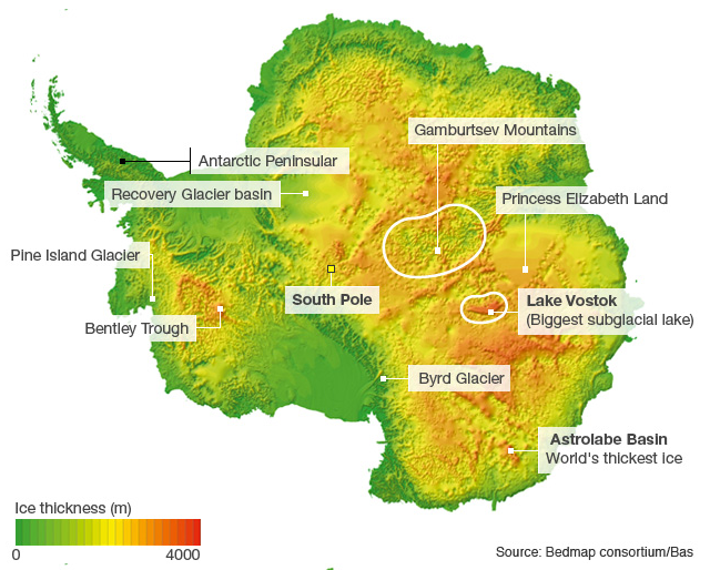
Scientists have their best measure yet for the amount of ice in Antarctica.
A detailed analysis of data compiled during 50 years of exploration shows the White Continent to contain about 26-and-a-half-million cubic km.
It is a colossal volume, and to put that in some sort of context: if this ice was all converted to liquid water, it would be sufficient to raise the height of the world's oceans by 58m.
These numbers come out of an international project known as Bedmap2, external.
This large cooperative effort - involving 60 scientists from 35 institutions based in 14 countries - has sought to put tighter constraints on some of Antarctica's fundamental statistics.
Bedmap2's new figure for the volume of ice is 4.5% more than previously thought.
Interestingly, the sea-level-rise equivalent is not that different to past estimates. This is because the extra ice is shown to lie mostly below the current water line and so if it melted it would not add significantly to the volume already displaced.
One way to display all this information is in the thickness map seen at the top of this page. It neatly illustrates the vast scale of the ice sheet covering Antarctica.
The thickest point is in a place called Astrolabe Subglacial Basin. There, the column of ice is 4,776m thick.
In principle, the above map is simple enough to render provided you know the shape of the continent's rock bed and the height of the overlying ice. You subtract one from the other.
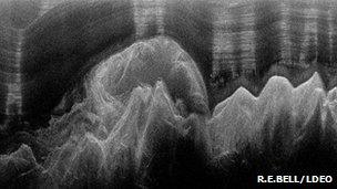
Radar can be used to map mountains buried under hundreds of metres of ice
Satellites in recent years have vastly improved our understanding of ice elevation, but visualising the rock underbelly of Antarctica has been a herculean endeavour spread over five decades.
"A multitude of different types of data have been used to construct the sub-ice surface," said Peter Fretwell from the British Antarctic Survey (BAS), which is part of the Bedmap Consortium.
"These include: radio-echo sounding data from airborne and ground based sources, seismic surveys, swath and gridded bathymetric data, satellite elevation data, pre-gridded elevation datasets, contour data from rock outcrops, glacier profiles, grounding lines and visual interpretation of the ice sheet-ice shelf interface.
"The ice thickness model alone uses 25 million individual survey points," he told BBC News.
The Bedmap project is in its second iteration, and its numbers for Antarctic ice, published in The Cryosphere journal, external, are an update on what was the state of knowledge in 2001.
It is essential baseline information for anyone trying to model the White Continent's response to future climate change.
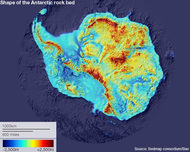
Getting an accurate visualisation of the rock bed has taken more than five decades
In comparison to Bedmap1, the total volume of ice calculated for Bedmap2 has risen by 1.2 million cu km to 26.54 million cu km. If you include the floating shelves of ice that jut out into the ocean, the total is very nearly 27 million cu km.
But from the new data available to Bedmap2, it is now clear the mean elevation of the rock bed is substantially lower than was understood previously - down from 155m to 95m above sea level. This is the explanation for why most of that extra ice volume (much of it in East Antarctica) is known to lie under water. The whole ice sheet is sitting lower than we thought.
However, the fact that more ice rests below sea level means that on millennial timescales, increased amounts of ice are potentially vulnerable to ocean melting. It is now recognised that most of the ice being lost from Antarctica is going as a result of warm water eating the fringes of the continent. It is not a consequence of higher air temperatures, but from changes in ocean circulation caused by atmospheric forcing. This is evident, for example, in the rapid thinning seen of late in the mighty Pine Island Glacier in West Antarctica.
The Bedmap2 project has benefited greatly from the large number of airborne radar surveys that have been flown in the past decade or so.
Unlike rock, ice is transparent to radar. So by firing radio pulses through the overlying sheet and recording the return echoes, scientists can plot both the depth of the rock bed and - by definition - the thickness of the ice covering.
Instrumented planes, guided by GPS, fly back and forth across the ice in campaigns that can last weeks at a time.
Perhaps the most publicised of these recent efforts was the multinational expedition in 2007/2008 to map the Gamburtsev mountains.
This range is the size of the European Alps with the tallest peaks reaching 3,000m above sea-level - and yet they are still hidden below more than a 1,000m of ice.
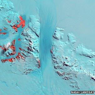
Byrd Glacier is where the rock bed reaches its lowest elevation at 2,870m below sea level
The Gamburtsev survey filled in a huge region of uncertainty, but there remain a number of areas of the continent where the rock-bed profile is still poorly understood.
You can see some of them in the ice thickness map - places where the data appears smudged. Two of the biggest data deficits are centred on Recovery Glacier Basin, just south of the Shackleton mountain range, and between the Gamburtsevs and the coast - a region known as Princess Elizabeth Land.
Bids are being made to major science funding agencies in the US and Europe to close these knowledge gaps.
Glaciologist Helen A Fricker from the Scripps Institution of Oceanography is not connected with the Bedmap Consortium.
She said the project's work was of paramount importance.
"We've got all these computer models that are making predictions about what is going to happen to the ice sheet in the future, giving us estimates of sea-level rise. That's all very well, but if the models don't have the basic parameters for what the ice looks like, we're not going to get the right answers out," Prof Fricker told BBC News.
"The reason we're really excited about Bedmap2 is because some of the holes in the data that existed in Bedmap1 have now been beautifully resolved."
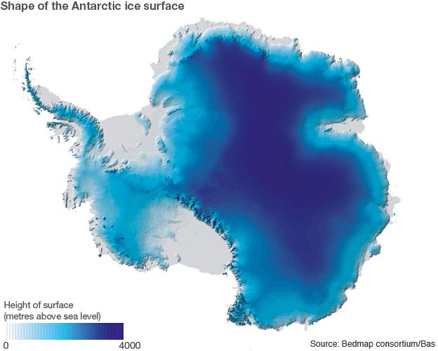
In recent years, satellites have given us a very good assessment of the height of the ice surface
Jonathan.Amos-INTERNET@bbc.co.uk and follow me on Twitter: @BBCAmos, external
- Published25 April 2012
- Published5 December 2011
- Published19 August 2011
- Published3 March 2011