More climate records fall in world's warmest February
- Published
- comments

Last month was the world's warmest February in modern times, the EU's climate service says, extending the run of monthly records to nine in a row.
Each month since June 2023 has seen new temperature highs for the time of year.
The world's sea surface is at its hottest on record, while Antarctic sea-ice has again reached extreme lows.
Temperatures are still being boosted by the Pacific's El Niño weather event, but human-caused climate change is by far the main driver of the warmth.
"Heat-trapping greenhouse gases are unequivocally the main culprit," stresses Prof Celeste Saulo, Secretary General of the World Meteorological Organization.
Carbon dioxide concentrations are at their highest level for at least two million years, according to the UN's climate body, and increased by near-record levels again over the past year.
Those warming gases helped make February 2024 about 1.77C warmer than "pre-industrial" times - before humans started burning large amounts of fossil fuels - according to the EU's Copernicus Climate Change Service.
This breaks the previous record, from 2016, by around 0.12C.
These temperatures saw particularly severe heat afflict western Australia, southeast Asia, southern Africa and South America.

The 12-month average now sits at 1.56C above pre-industrial levels - after the first year-long breach of 1.5C warming was confirmed last month.
Back in 2015 in Paris, nearly 200 countries agreed to try to keep the rise in warming under 1.5C, to help avoid some of the worst climate impacts.
That threshold in the Paris agreement is generally accepted to mean a 20-year average - so it hasn't yet been broken - but the relentless string of records illustrates how close the world is getting to doing so.
Oceans and sea-ice under strain
Recent records haven't just been limited to air temperatures. Countless climate metrics are far beyond levels seen in modern times.
One of the most notable is sea surface temperatures. As the graph below shows, the margin of records in recent months has been particularly striking.

Researchers are keen to stress that the scale and extent of the oceanic heat is not simply a consequence of the natural weather event known as El Niño, which was declared in June 2023.
"Ocean surface temperatures in the equatorial Pacific clearly reflect El Niño. But sea surface temperatures in other parts of the globe have been persistently and unusually high for the past 10 months," explains Prof Saulo.
"This is worrying and cannot be explained by El Niño alone."
Ocean warming has prompted concerns about the mass bleaching of coral reefs. It also raises global sea-levels and can help to fuel higher intensity hurricanes.
Unusually warm waters may also have been a factor in another exceptional month for Antarctic sea-ice. The three lowest minimum extents in the satellite era have now occurred in the last three years.

Scientists are struggling to explain exactly what's going on.
Until 2017, Antarctic sea-ice had defied predictions that it would shrink, unlike in the Arctic, where the downward trend has been much clearer.
The apparent recent shift - occurring at the same time as other records are being broken around the planet - adds to concerns that Antarctic sea-ice may finally be waking up to climate change.
"I don't think you can say it's coincidental," Prof Martin Siegert, a glaciologist at the University of Exeter, told BBC News.
"It's absolutely frightening. The records are just off [the] scale."
An end to El Niño in sight
There are signs that the run of global temperature records may finally come to an end in the months ahead.
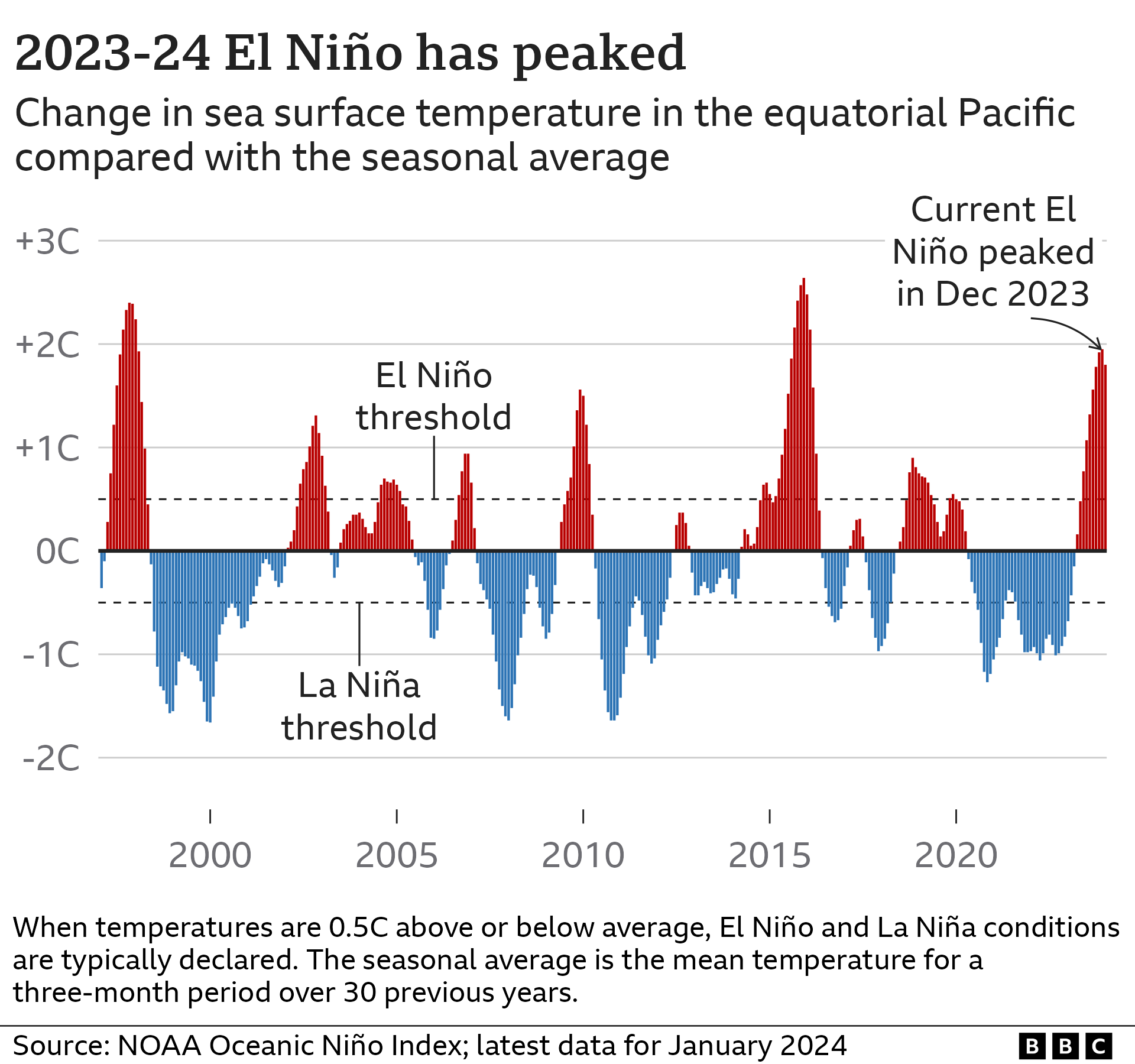
The 2023-24 El Niño has been one of the five strongest such events on record, the World Meteorological Organization announced on Tuesday, but it is gradually weakening.

El Niño will continue to have an effect on temperatures and weather patterns for the next few months.
"We would expect [El Niño] to continue to keep 2024 temperatures elevated at least through the first half of the year," Dr Colin Morice, a senior scientist at the UK's Met Office Hadley Centre, told BBC News.
However, a switch to neutral conditions in the Pacific is likely between April and June, according to US science body NOAA, and a further switch to the cool phase known as La Niña could then happen between June and August.
This would likely put a temporary lid on global air temperatures, with a cooler sea surface in the East Pacific allowing less heat to escape and warm the air.
But as long as human activities keep releasing huge amounts of greenhouse gases, temperatures will continue rising in the long-term, ultimately leading to more records and extreme weather.
"We know what to do - stop burning fossil fuels and replace them with more sustainable, renewable sources of energy," says Dr Friederike Otto, senior lecturer in climate science at Imperial College London.
"Until we do that, extreme weather events intensified by climate change will continue to destroy lives and livelihoods."
- Published1 March 2024

- Published8 February 2024

- Published9 January 2024

