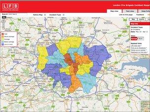
'First' fire incidents map goes online in London
- Published

A map showing the number of the fire related incidents across London has been made available online.
The London Fire Brigade said people can type in their postcodes to get the data on how many fires, traffic accidents and other incidents firefighters have been called to in the past year.
The fire map, external shows Croydon in south London had the most serious fires and arson attacks.
The brigade said it was the first fire map in the UK.
It is based on the Metropolitan Police's crime map, external which went online in 2008.
The London Fire Brigade (LFB) hopes the map will encourage residents, businesses and councils in places with a higher number of incidents to take action to make their area safer.
Susan Hall, chairwoman of London Fire Authority's Community Safety Committee, said: "London's firefighters have done an excellent job of making the capital safer in recent years but there are still some areas that are having too many fires.
"The map shows that fires happen each and every day across London - what better incentive could there be for people to make sure it doesn't happen to them?"
- Published10 May 2011
- Published5 May 2011