Can mapping conflict data explain, predict and prevent violence?
- Published

It was December 2015, and Dr Weisi Guo was having dinner and listening to the grim news about the conflict in Syria.
Over the previous decade, Dr Guo had grown increasingly troubled by the amount of violence towards civilians. He had worked in UNHCR refugee camps in Algeria and seen the human cost at first hand.
His own expertise - as an academic specialising in communication networks and telecoms - seemed a world away. But as a physical scientist he wanted a model to help understand the nature of conflict, and so a highly innovative approach began to take shape.
That night he looked at a map of where the Islamic State group was operating and noticed an overlap with locations on the old Silk Road - the route that had taken traders from China through Asia and the Middle East to the Mediterranean thousands of years ago.
"What I slowly started to notice was that a lot of these areas prone to repeated violence were along ancient trade routes. And I thought, 'Is there a reason to this?'"
That night he wrote an algorithm on his laptop that connected the locations of cities and towns, and mapped them against data about conflict sourced from The Global Terrorism Database, external and The Peace Research Institute Oslo (PRIO), external.
"The results were amazing," he says. His first reaction was to assume that he had made a mistake, and so he tried again. The results were better. He asked a mathematician colleague to run an independent test, which generated the same answers.
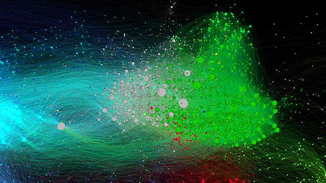
Dr Guo's algorithm connected the world as a mesh of towns and cities, and looked at the connections between them. In Dr Guo's graph, certain towns show up as larger circles signifying dense connections.

On a whiteboard he draws a map of connected cities, and points out that if a traveller from each city wanted to walk round the map they would collide 100 times more often at certain crossroads than other places.
Inherent instability?
They are the places you have to go through in order to get from one town to another and where there are few other routes - hence the correlation with the Silk Road.
What he found was that these correlated strongly with data on violence - including terrorism, war between states and gang violence. Crossroad towns and cities, it suggested, were inherently unstable.
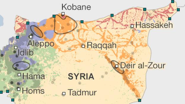
Syria shows up strongly - as a pathway up from Africa through the Levant and also for traffic from Asia.
The relatively small town of Deir al-Zour in Syria correlates very highly - until recently it was one of the last holdouts for IS.

"It is an isolated crossroads between both regional civilisations [Syria and Iraq], and for the world as a whole, connecting western Eurasia with the Far East," explains Dr Guo.
"Indeed, historically it was an important trading post between the Roman Empire and India. Later on, it was a key Silk Road junction, connecting the orient with both Egypt and Europe."
Dr Guo's model is controversial. It puts significantly more emphasis on the physical geography of areas rather than other social, cultural or religious factors which might more traditionally be explored as a way of trying to understand conflict.
But he believes that his theory can scale up to a global level.
The Middle East is the most obvious regional crossroads, both on an east-west axis - linking Asia to Europe - and also north-south coming up from sub-Saharan Africa.
But the same is also true of the narrow corridor in Central America connecting North and South America - the region from Colombia through to the US-Mexican border.

President Trump famously promised to build a wall along the US-Mexican border during his election campaign to reduce migration
The hypothesis he is pursuing is that certain areas have more contentious ideas flowing through them than other areas, and that somehow destabilises them.
Dr Guo is careful not to say that cultural diversity is an inevitable instability factor for societies, but areas with a lot of movement - whether in culture, trade, ideas or people - do appear to correlate with risk.
"On average, across the world [in 2017], 76% of all terrorist attacks happened within the actual cities where we predicted [in 2016] that they would happen - and around 90% within 50km of the cities. That's the level of predictive accuracy," he says.
What is interesting about the topographical approach is that it offers possible ways of reducing propensity to conflict.
Too often, Dr Guo argues, planners think locally. "You have to zoom out a bit, and think about the global flux," he argues.
'Choke points'
One possible response could be to reduce the pressure and strain on certain towns and cities by creating routes that bypass them. That could be through physical infrastructure like roads or even new towns and cities, or perhaps via new communication or even cultural links.
This may be particularly important in areas coming out of conflict when there is an opportunity to rebuild in a way which minimises the risk of future violence.
But, he acknowledges, this is not always easy. "These 'choke points' are very challenging to bridge, and strategically very important," Dr Guo says. He points out that creating bypasses at some key choke points would involve spanning deserts or a sea.

The Myanmar-Bangladesh border has come under pressure from hundreds of thousands of Rohingya fleeing violence in Rakhine state
Dr Guo spends a fifth of his time as a Turing Fellow at the Alan Turing Institute in London, which allows him to collaborate with some of the world's leading data scientists.
His co-investigator on this project is Sir Alan Wilson, who has a long track record in the mathematical modelling of physical spaces.
The two men met serendipitously at a Turing workshop, and immediately realised they needed to work together. Other project partners include GCHQ and the Ministry of Defence.
Dr Guo is also working with collaborators in Mexico and Colombia looking at drug-trafficking routes.
So far the work uses data from the past 15 years - primarily because since 9/11 there is a larger and more coherent dataset for conflict.
Before that, Dr Guo says, data was pretty sparse and often poorly geo-tagged.

Dr Guo's mapping technique is being used to explore South American drug trafficking routes
However, what seems most tantalising is this potential ability to predict where future conflict may erupt, although Dr Guo is cautious about making public forecasts at this stage.
Another fruitful area could be to look at places which the model suggests should see conflict - but where it has not taken place - and ask why.
In some cases, political factors - such as a powerful police state - may provide an answer.
'Marmite' model
The model also raises the question of the impact of blockades and embargos.
If countries are cut off from others, then the model suggests they should become more stable and coherent, since there will be minimal traffic passing through. But what happens when these isolated countries open up? How would you counter the risk of instability that might pose?
Dr Guo acknowledges that his model is somewhat "Marmite" and divides opinion. "Either this is conventional wisdom… or this is something really dumb," he says.
Others who work in the field of conflict research and who have looked at the studies say they are an interesting way of looking for new angles on well-known problems.

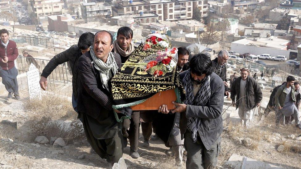
The conflict in Syria has devastated many cities, including Aleppo, and has displaced millions of people
"It is not mainstream," acknowledges Prof Kristian Gleditsch from the University of Essex.
"Many social scientists might be sceptical that these approaches are useful. But I do think this can be useful, and can draw attention to ways of seeing the problem differently than within traditional conflict research."
Those taking a more qualitative approach criticise it as reductionist, arguing that it takes a hugely complex human problem with many layers and oversimplifies it, eliminating the role of historical factors.
But Dr Guo believes that starting from something simple with a strong predictive power provides a basis on which to build further knowledge and explore the correlations and possible causes.
His hope is ambitious: that an evidence base can be created which will help sustainable development of infrastructure on a truly global basis, and in doing so reduce conflict significantly.
- Published2 February 2018
- Published31 January 2018
- Published1 September 2015

- Published10 July 2015
- Published28 August 2014