Tropical Storm Barry: Flooded New Orleans braces for likely hurricane
- Published
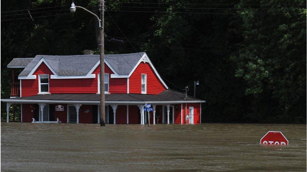
New Orleans has already been hit by flooding
Tropical Storm Barry, which is currently moving over the Gulf of Mexico, is likely to develop into a hurricane.
It is forecast to hit the US city of New Orleans, which has already seen thunderstorms and flash floods.
A state of emergency is in effect and residents in some low-lying areas have been asked to evacuate.
The Mississippi river could come dangerously close to overtopping banks shielding the city, officials warn.
It could rise as high as 20ft (6m) above sea level, they say, potentially exceeding the 20-25ft levees which protect the river from overflowing.
"We're confident the levees themselves are in good shape. The big focus is height," Ricky Boyett, a spokesman for the US Army Corps of Engineers, which maintains the fortifications, told AP news agency.

A waterspout was spotted over Lake Pontchartrain

Heavy rains have already brought flash flooding to the city
Flash flooding
On Wednesday morning, the New Orleans metro area was hit by as much as eight inches of rain over a three-hour period.
Swamped streets saw rubbish bins overturned and vehicles flooded. Some parts of the city saw streets turn into lakes as deep as four feet. Kayakers were seen paddling on roadways.
The National Hurricane Center said on Thursday morning that the storm was 95 miles south-east of the mouth of the Mississippi, with maximum windspeeds of 40mph (64 km/hr).
Tomasz Schafernaker takes a look at the formation of Cape Verde-type hurricanes and where their energy comes from.
When winds hit 74mph it will be declared a hurricane, which is predicted to happen before it makes landfall in the delta of the Mississippi River on Friday.
The storm is predicted to dump 10-15 inches of rain on Friday and Saturday along the Louisiana coast and parts of Texas.
Allow X content?
This article contains content provided by X. We ask for your permission before anything is loaded, as they may be using cookies and other technologies. You may want to read X’s cookie policy, external and privacy policy, external before accepting. To view this content choose ‘accept and continue’.

Residents have been warned to stock up on drinking water and non-perishable food, as well as other emergency supplies.
Plaquemines Parish, south of New Orleans, has ordered residents to evacuate. Vermilion Parish, to the west of the city, has asked some people living in low-lying areas to consider moving to higher ground.

Residents are asked to keep drains clear so water can quickly pass through
Storm surges are expected to see rivers and tides crest at levels far higher than average, officials warn.
The primary danger is in the amount of water from surges and rainfall rather than wind damage, emergency responders say.
The danger has been compounded by the abnormally high levels of water in the Mississippi, which is swollen from months of above-average rainfall.
Tropical Storm Barry is currently "moving very slowly to the west at 5mph" the National Weather Center warned in an advisory on Thursday.
It said the storm could produce tornados along southern portions of Louisiana and Mississippi.
Allow X content?
This article contains content provided by X. We ask for your permission before anything is loaded, as they may be using cookies and other technologies. You may want to read X’s cookie policy, external and privacy policy, external before accepting. To view this content choose ‘accept and continue’.
Officials warn that even if the storm does not form into a hurricane, heavy rain could still create dangerous conditions lasting for days.
"No one should take this storm lightly," said Governor John Bel Edwards as he declared a state of emergency.
"As we know all too well in Louisiana, low intensity does not necessarily mean low impact."

How is New Orleans preparing?
New Orleans Mayor Latoya Cantrell said the city's anti-flood water pumps are working at "optimal capacity", but cautioned: "We cannot pump our way out of the water levels and the waterfalls that are expected to hit the city of New Orleans."
She, and other city officials, asked people to bring in their rubbish bins and clear yards and streets in order to prevent debris from choking street drains and gutters or becoming airborne "projectiles".
New Orleans Police Superintendent Shaun Ferguson said officers were "all hands of deck" and said all leave had been cancelled for police officers.
He asked people to remain in their homes and not to attempt to drive their car through standing water due to the danger of being swept away or stranded.

Fire officials warn that in the event of a power outage, residents should be careful not to overheat or mismanage electrical generators, and should refrain from using candles unless necessary due to the danger of sparking a fire.
The National Guard has sent a large contingent to New Orleans to assist in rescue and recovery operations, and to transport equipment into the city.
- Attribution
- Published1 October 2016

- Published11 June 2019