How to get to the Eisteddfod Maes
- Cyhoeddwyd

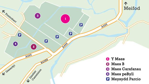
Check out our map of the area around the Eisteddfod with information on how to get to the Maes.
The Maes address is Mathrafal Farm, Meifod, Powys. SY22 6HT.
Map Key:
1. Y Maes - festival site
2 & 4. Maes B , dolen allanoland adjoining campsite
3. Caravan site
P. Parking
How to get to the Maes
Traffic travelling from the north east, follow the A5 to Oswestry then the A48. At Llynclys turn right onto A495. At the junction, follow the yellow EISTEDDFOD signs to the Maes.
Traffic from the north west, follow the A470 to Brigands Inn roundabout near Dinas Mawddwy and then the A458. At Neuadd Bridge turn left onto A495. At the junction, follow the yellow EISTEDDFOD signs to the Maes.
Traffic from the west should, follow the A489 to Cemmaes Road, turn left onto the A470. Follow the A470 to Brigands Inn roundabout near Dinas Mawddwy and then A458. At Neuadd Bridge turn left onto A495. At the junction, follow the yellow EISTEDDFOD signs to the Maes.
Traffic from the south, follow the A470 to Caersws then the A483 to Welshpool then the A458. At Heniarth, turn right onto B4389. At the junction, follow the yellow EISTEDDFOD signs to the Maes
Follow the signs to the designated car parks and please do not park on the roadside. Parking at the Eisteddfod is free of charge.
Blue badge holders should follow the signs to the disabled car park.
Public transport
If travelling by rail, the nearest station is Welshpool. Special service buses to the Maes will be running during the Eisteddfod week. Please note this is not a free service. For more details, visit the Eisteddfod website, dolen allanol.